


Dr Stamatis Stamatiadis: “The best yield, at the least cost to the farmer and the environment”
The integrated variable nitrogen supply system is a project funded by Sub-measure 16.1-16.5 of Measure 16 ‘COOPERATION’
The purpose of Measure 16 is cooperation. The goal of Sub-measure 16.1-16.5, in which we are participating, is to enhance environmental protection and adaptation to climate change.
The measure supports the development of partnerships aimed at linking research and production, through the pilot implementation of projects by Operational Teams. So, in order to link research to production and actively contribute to the goal of environmental protection, we collaborated with ELGO-DIMITRA’s Agricultural Research Institute in Larissa, ‘GAIA EPICHEIREIN’, an agricultural sector consulting company that specialises in, among other things, knowledge promotion and dissemination in the rural world, ‘PRO DEPOT’, a technology company that can support us with the very sophisticated remote sensing systems and, lastly, the ‘Thesgi’ Agricultural Cooperative in Larissa, which will translate the results of the project into practice on the field.
More specifically, our business plan is to improve nitrogen use efficiency through an integrated variable nitrogen supply system.
This has been a research effort many years in the making. In the 1990s, we started by researching soil quality using various measurement indicators to evaluate soil quality and, consequently, crop health. Through a partnership with University of Nebraska, US, we combined technology with these metrics. In other words, we saw that remote sensing enables us to measure certain soil and plant properties remotely.
This has huge advantages, and I’ll explain why. Normally, to measure the quality of the soil, we need to use samplers, take samples, bring them to the laboratory, and analyse them. The same holds true for plants.
On the other hand, through remote sensing we can measure many properties accurately at a distance. This is done by evaluating the wavelengths of light we get from the sensors. Besides reducing the cost of the process, we can have accurate spatial distribution of the properties, per metre of soil, which could not be done using conventional methods. Practically, how many samples can you analyse, if you have large areas?
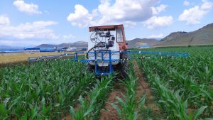
By securing all the information provided by a sensor about the nitrogen content in the plant, for example, which, however, changes spatially, you might be able to develop algorithms per metre related to the needs of the plant and translate that information into fertiliser doses.
Thus, the spreader on the tractor is able to drop the necessary dose and all this, namely, collection, processing, transmission of the information, and its translation, must be done very quickly. The sensors, the computer system, the electronics and the controllers, the fertiliser and the spreader, all in sequence, must work in fractions of a second, while the tractor moves accurately. In our system, this accuracy, I would say, is unique, internationally, and the nitrogen doses change every metre.
Doses of nitrogen that are equal to the doses spread by the farmer are only required in small portions of the field. Throughout the rest of the holding they are much smaller, as the system realises that it does not take that large a dose for the crop to reach cost-optimal yield. Measurements so far indicate that we may have a 20%-30% reduction in the total amount of fertiliser used by the farmer.
At the same time, we have major environmental benefits that are not unrelated to financial benefits. Indicatively, to clean up groundwater or surface water due to overfertilisation, you need huge amounts of capital. Furthermore, producers are also subsidised when they use less fertiliser, due to the losses this represents for their production. However, with this system, they will have no losses.